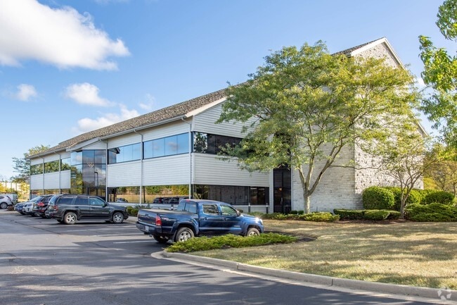
Property Record
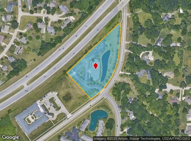
7333 Paragon Rd, Dayton, OH 45459

NEARBY LISTINGS FOR SALE OR LEASE
Property Detail
7333 Paragon Rd
Dayton, OH
Normandy Lakes Corporate Park
O67-28723-0001
1 NORMANDY LAKES CORPORATE PARK SEC 1
Officebuilding
Montgomery
X
Ohio
39113C0268E
1
2023
4.29 AC
2024
South Dayton
040401
Cincinnati/Dayton
27,362 SF
DEMOGRAPHICS near 7333 Paragon Rd
1 Mile
3 Mile
5 Mile
2024 Total Population
6,024
60,462
167,674
2029 Population
5,897
59,386
166,487
Pop Growth 2024-2029
(2.11%)
(1.78%)
(0.71%)
Average Age
45
44
42
2024 Total Households
2,559
27,177
72,153
HH Growth 2024-2029
(2.23%)
(1.71%)
(0.91%)
Median Household Inc
$71,764
$78,741
$80,200
Avg Household Size
2.20
2.20
2.30
2024 Avg HH Vehicles
2.00
2.00
2.00
Median Home Value
$230,654
$247,647
$229,552
Median Year Built
1974
1977
1975
Nearby Places
Map Layers
Map Styles
 Street
 Aerial
- Restaurants
- Banks
- Shops
- Fitness
- Groceries
PUBLIC TRANSPORTATION
AIRPORT
James M Cox Dayton International
DRIVE
WALK
Distance
James M Cox Dayton International
38 min
22.4 mi
SALE & LEASE HISTORY
LISTING DATE
SALE/LEASE

Nov 30, 2016
For Lease
May 13, 2022
For Lease
Mar 25, 2021
For Lease
Dec 05, 2022
For Lease
Dec 03, 2024
For Lease
Aug 08, 2019
For Lease
Nearby Properties
Address
Land Use
TOTAL SIZE
Lot Size
Zoning
Address
Land Use
TOTAL SIZE
Lot Size
Zoning
25,715 SF
23.28 AC
Address
Land Use
TOTAL SIZE
Lot Size
Zoning
1,042,121 SF
51.37 AC
Address
Land Use
TOTAL SIZE
Lot Size
Zoning
42.40 AC
Address
Land Use
TOTAL SIZE
Lot Size
Zoning
462,864 SF
38.86 AC
Address
Land Use
TOTAL SIZE
Lot Size
Zoning
191,667 SF
35.98 AC
Address
Land Use
TOTAL SIZE
Lot Size
Zoning
490,354 SF
60 AC
Address
Land Use
TOTAL SIZE
Lot Size
Zoning
59,658 SF
74.94 AC
Address
Land Use
TOTAL SIZE
Lot Size
Zoning
5,461 SF
10.35 AC
Address
Land Use
TOTAL SIZE
Lot Size
Zoning
47,552 SF
47.55 AC
Address
Land Use
TOTAL SIZE
Lot Size
Zoning
203,122 SF
4.63 AC
Address
Land Use
TOTAL SIZE
Lot Size
Zoning
18.33 AC
Address
Land Use
TOTAL SIZE
Lot Size
Zoning
318,347 SF
26.75 AC
Address
Land Use
TOTAL SIZE
Lot Size
Zoning
142,887 SF
15.25 AC
Address
Land Use
TOTAL SIZE
Lot Size
Zoning
1,042,121 SF
51.37 AC
Address
Land Use
TOTAL SIZE
Lot Size
Zoning
272,855 SF
29.01 AC
Address
Land Use
TOTAL SIZE
Lot Size
Zoning
81,787 SF
45.38 AC
Address
Land Use
TOTAL SIZE
Lot Size
Zoning
198,030 SF
22.32 AC
Address
Land Use
TOTAL SIZE
Lot Size
Zoning
138,484 SF
23.04 AC
Address
Land Use
TOTAL SIZE
Lot Size
Zoning
89,683 SF
33.45 AC
Address
Land Use
TOTAL SIZE
Lot Size
Zoning
24,928 SF
13.67 AC
Address
Land Use
TOTAL SIZE
Lot Size
Zoning
10.33 AC
Address
Land Use
TOTAL SIZE
Lot Size
Zoning
137,948 SF
4.60 AC
Address
Land Use
TOTAL SIZE
Lot Size
Zoning
Address
Land Use
TOTAL SIZE
Lot Size
Zoning
10,912 SF
15.28 AC
Address
Land Use
TOTAL SIZE
Lot Size
Zoning
109,775 SF
1.25 AC
Address
Land Use
TOTAL SIZE
Lot Size
Zoning
236,103 SF
7.28 AC
Address
Land Use
TOTAL SIZE
Lot Size
Zoning
148,369 SF
14.69 AC
Address
Land Use
TOTAL SIZE
Lot Size
Zoning
88,556 SF
23.94 AC
Address
Land Use
TOTAL SIZE
Lot Size
Zoning
82,510 SF
12.79 AC
Address
Land Use
TOTAL SIZE
Lot Size
Zoning
44,736 SF
18.32 AC
The World's #1 Commercial Real Estate Marketplace
Connect with us
© 2025 CoStar Group
The information above has been obtained from sources believed reliable. While we do not doubt its accuracy we have not verified it and make no guarantee, warranty or representation about it. It is your responsibility to independently confirm its accuracy and completeness. Any projections, opinions, assumptions, or estimates used are for example only and do not represent the current or future performance of the property. The value of this transaction to you depends on tax and other factors which should be evaluated by your tax, financial, and legal advisors. You and your advisors should conduct a careful, independent investigation of the property to determine to your satisfaction the suitability of the property for your needs.